 2023, Vol. 41
Institute of Oceanology, Chinese Academy of Sciences
Article Information
- HUANG Zhe, XU Haijue, BAI Yuchuan, SHI Fengshuo, WEN Zhichao
- Coastline changes and tidal current responses due to the large-scale reclamations in the Bohai Bay
- Journal of Oceanology and Limnology, 41(6): 2045-2059
- http://dx.doi.org/10.1007/s00343-022-2235-6
Article History
- Received Jun. 7, 2022
- accepted in principle Sep. 21, 2022
- accepted for publication Oct. 28, 2022


2 Institute for Sedimentation on River and Coastal Engineering, Tianjin University, Tianjin 300350, China
Coastal areas are inhabited by nearly one-third of the world' s population and are becoming more urbanized (Tian et al., 2016; Cao et al., 2020). To seek more residential and production spaces, land reclamation is widely conducted to expand coastal areas (Hu et al., 2018). Under reclamation activities, the coastline shapes and nearshore topography have all been significantly changed (Ding et al., 2019). The natural quality of the coast may also be permanently deteriorated with these interferences in nearshore hydrodynamics (Feng et al., 2014; Zhu et al., 2017a; Gao et al., 2018; Hu et al., 2018). Therefore, land reclamation and its impacts are receiving extensive attention worldwide (Manda and Matsuoka, 2006; Kang et al., 2013; Kuang et al., 2013; Ding and Wei, 2017).
Reclamation-induced tidal current changes are the most obvious consequences in hydrodynamics (Wang et al., 2013; Gao et al., 2014; Lin et al., 2015). These consequences are reflected in many aspects. The sea area is reduced due to the space that is taken up by reclamation, which decreases the tidal prism for semi-enclosed bays (Wang et al., 2013; Yang and Chui, 2017). Additionally, the tidal energy entering the bays and the average water depth decrease, leading to a slight decrease in the current velocity (Wang et al., 2013; Gao et al., 2014; Xu et al., 2021). While, the tidal current field will correspondingly change with spatiotemporal variations in the symmetry of tidal durations (Gao et al., 2014; Yu et al., 2016) and their spatial distributions (Lin et al., 2015). In addition, many researchers have focused on dominant tidal constituents, such as the M2 tide. It is generally concluded that reclamation has only a slight impact on the amplitude and phase of the M2 system (Lou et al., 2009; Gao et al., 2014; Suh et al., 2014). However, these changes may be diverse in different types of bays. Tidal current changes are important issues to be considered because they may have impacts on sediment transport, water ecological evolution and so on (Gao et al., 2018; Deng et al., 2020).
Bohai Bay is a typical semi-closed bay in China that suffers severe significant impacts from land reclamation (Ding et al., 2019). Since 2000, its coastline has changed greatly with the construction of multiple reclamation projects, such as the Caofeidian, Tianjin Binhai, and Huanghua ports. The front edge of the reclamation has reached the -5-m isobath, and the greatest intrusion distance can reach 20 km (Hou et al., 2017). These projects have obvious impacts on the tidal current field. Recently, the tidal prism has decreased by nearly 10%, the residual current has been weakened, and the M2 tide has shifted (Hou et al., 2017; Jia et al., 2018). These changes have also caused many ecological problems, such as the weakening of water exchange capacity (Yuan et al., 2015) and the migration of nutrients, heavy metals, and other pollutants (Zhu et al., 2017a, 2018; Jiang et al., 2018; Wang et al., 2018). However, most studies focus on one of the multiple reclamation projects and are limited to only the area adjacent to the project. The Caofeidian Port is typically reported as an example in studies of the symmetry of tidal currents and velocity changes (Lu et al., 2009; Liang et al., 2018), as is the Huanghua Port, for which studies have focused on sediment deposition (Kuang et al., 2015). However, the influence ranges of these projects are unclear in these studies. In addition, land reclamation with many breakwaters or deep-water channels will lead to local sediment erosion or deposition due to main driving force changes in the magnitude and direction of the tidal currents (Gao et al., 2018; Jia et al., 2018). However, the existing studies do not sufficiently address this. It is also necessary to synergistically supplement the research on the influence of reclamation on the dominant M2 tide because much attention has been focused on the amplitude and symmetry of the M2 tide, while the steering and influence range has been ignored (Hou et al., 2017; Liang et al., 2018).
In this research, a shelf-improved numerical model is established in Bohai Bay for both pre- and post- reclamation conditions. The coastline changes in the bay are detected through remote sensing images as the baseline and boundary conditions for the numerical model. The object of this paper is to investigate the changes and influence range of the basic tidal current due to multiple reclamation projects and the characteristics of the M2 tide through harmonic analysis. The results will provide a reference for a deep understanding of the synergistic impact of multiple reclamation projects and for further planning of these projects.
2 METHOD 2.1 Study areaBohai Bay is located in northern China and is the western component of the Bohai Sea (shown in Fig. 1). It is a large semi-enclosed bay that is surrounded by land on three sides. The bay, located in 117°35′E–118°51′E and 38°00′N–39°14′N, ranges from the old Huanghe (Yellow) River estuary in Shandong Province to the Luanhe River estuary. The mean water depth in the bay is 12.5 m, and the mean tidal range is 2.4 m, as observed at Tianjin Port (Wang et al., 2018). In the 21st century, the demand for land resources has intensified in this coastal area, with both economic and political drivers leading to permanent changes in the coastline and appropriation of oceanic resources (Zhu et al., 2017b). The main reclamation projects have mainly occurred in the Tianjin Binhai New Area, Caofeidian Industrial Zone, and Huanghua Port, as shown in Fig. 1. Among these projects, the reclamation of Caofeidian for the Economic Demonstration Zone and deep-water ports in the coastline began in 2005. By the end of 2013, the reclamation area exceeded 200 km2, resulting in changes in the hydrodynamics and the sediment environment. The reclamation of the Tianjin Binhai New Area for the Port Industrial Park and Logistics Park started almost at the same time as the Caofeidian reclamation project. The reclamation projects were distributed in several locations, such as Beijiang, Dongjiang, and Nanjiang, as blocks for water exchange in the offshore area (Yuan et al., 2015). The reclamation around Huanghua Port, mainly for port construction, aquaculture, and salt production, began around the year 2000. These reclamation efforts alleviated land use tensions and created economic benefits in the coastal area, but they also inevitably affected the coastal ecological environment around the projects (Zhu et al., 2017b).

|
| Fig.1 Schematic diagram of the study area The three images of the project areas are from the Landsat Satellite. |
Remote sensing images from the Landsat series with a resolution of 30 m are collected for the years 2000–2015 used for this study. The images are from the orbit numbers p121-r34 and p122-r33. All the images from each typical year (2000, 2004, 2011, and 2015) are extracted to determine the coastline changes.
ENVI software is used to conduct false colour composites on the satellite images to highlight the coastal area. Then, the terrain is classified on the composite images, through which the border between the land and water can be extracted. The border is the highest tide line among the extracted images in each typical year. Additionally, ArcGIS software is used to trim the coastline identified by ENVI. Notably, the coastline is not necessarily determined in strict accordance with the grid edge in the remote sensing images because of its tortuosity and inclination. The diagonal line of the grid is sometimes considered the final coastline, leading to the length of the coastline not being a multiple of 30 m.
2.3 Numerical model 2.3.1 Model settingThe numerical model of Bohai Bay is shown in Fig. 2. It is a spatially inlaid model. The large-scale model of the Bohai Sea is established (including Liaodong Bay, Bohai Bay, Laizhou Bay), with the open boundary at the line connecting Xiaochangshan Island in the north and the city of Weihai in the south. The model is discretized using triangle meshes, with the mesh and node numbers being 32 864 and 16 917, respectively, in 2015. The mesh size is approximately 3 000 m. The time span of the model is from February 10, 2000, to March 30, 2001, for the pre-reclamation period and from February 10, 2015, to March 30, 2016, for the post-reclamation period. The time step is set as 30 s. The open boundary condition is set as the water level process, which is determined with the Chinatide software (Li and Zheng, 2007). The land boundary is set as the fixed boundary.

|
| Fig.2 Numerical model settings for 2015 range and grid |
The small-scale model is consistent with the abovementioned study area. The open boundary is set at the line connecting the Luanhe River estuary and the old Huanghe River estuary. The mesh size is set as 1 000 m. The mesh and node numbers are 88 096 and 45 026, respectively, in 2015. The time span and time step are set to be consistent with the large-scale model. The open boundary of the small-scale model is obtained by interpolating the large-scale model with the whole Bohai Sea.
In calibrating the basic parameters of the Bohai flow field, the roughness of the bed is 0.015, according to previous studies (Sun and Tao, 2006; Wang and Dong, 2007; Hou et al., 2017). The pre-and post- reclamation water depth data in 2000 and 2015 are both collected from the nautical charts that are published by the Navigation Guarantee Department of the PLA Navy Headquarters.
2.3.2 Numerical methodA two-dimensional hydrodynamic model that includes equations of flow continuity (Eq.1) and momentum (Eqs.2–3) is established, by which the tidal current can be calculated during both the pre-and post-reclamation periods.
The continuity equation is:
 (1)
(1)The momentum equations are:
 (2)
(2) (3)
(3)In these equations, Z is the water level; U and V are the flow velocity components in the x and y directions, respectively; h is the water depth; f is the Coriolis force coefficient; g is the gravitational acceleration; and Cs is the Chezy coefficient.
The numerical model is solved with the shelf-improved finite element method based on the Fortran code that has been reported in our previous paper (Xu et al., 2020a, b). With this calculation, the tidal current field can be obtained for validation and analysis.
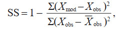
2.3.3 Model validationTwo evaluating parameters are used to verify the accuracy of the numerical model. The first is the skill score (SS), which is defined in Eq.4 (Song and Wang, 2013; Song et al., 2013). When SS>0.65, the model can be considered credible. The other parameter is the correlation coefficient (CC) (Xu et al., 2020a), which is defined in Eq.5. When CC>0.8, the simulated values are considered to be closely related to the measured values.
 (4)
(4) (5)
(5)In these equations, Xmod, is the simulated value of the model; Xobs is the measured value; and 

The water level and tidal current velocity in the numerical model are verified. The measured tidal level is collected from April 5 to April 8, 2000, and from the same period in 2015. As shown in Fig. 3, the computed tidal levels are consistent with the observed data, with an SS value greater than 0.79 and a CC value greater than 0.91. This indicates that the large-scale model accurately provides the open boundary of the water level for the small-scale model for both 2000 and 2015.

|
| Fig.3 Comparison of tide levels at three tide stations |
The small-scale model is verified with the measured current velocity and direction at eight points (shown in Fig. 1). The measured data are from 12꞉00 on May 18 to 14꞉00 on May 19, 2000, in the Tianjin Port hydrological observation stations. The measured and computed values are shown in Fig. 4. The comparison shows that most of the computed values coincide with the measured values. The overall SS is greater than 0.83 and the CC is greater than 0.94 for the current velocity and those for the current direction are greater than 0.87 and 0.93, respectively. The measured velocity of point #1 is greater than the simulated velocity. This phenomenon is due to its adjacent location to the Nanjiang and Dongjiang breakwaters, where the tide is weakened. In contrast, waves and wind are more likely to enhance the flow velocity. However, these two driving forces are not considered in the numerical model. In general, the small-scale model has a highly acceptable accuracy and can be applied to subsequent analysis.

|
| Fig.4 Comparison of measured and computed flow velocity (a) and direction (b) |
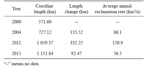
Figure 5 shows the coastline changes along Bohai Bay. The most significant changes occurred in the areas of Caofeidian, Tianjin Binhai, and Huanghua. These changes could be divided into three periods (as shown in Table 1 and Fig. 5). The coastline length and reclamation area showed various growth rates in the three periods.

|
| Fig.5 Temporal and spatial variation in the coastline of Bohai Bay (a) and in the three main areas of Caofeidian (b), Binhai New Area (c), and Huanghua (d) |
After 2000, small reclamation projects gradually and sporadically appeared in the bay. Most of the reclamation occurred on the southern coast, where mudflats are largely utilized for aquaculture and salt fields. This period continued until 2004, during which time the average reclamation rate was only 86.1 km2/a. The coastline correspondingly increased by 155.52 km, with few protrusions in the coastal area. During this period, the coastline also changed in the intertidal mudflat of the Binhai New Area and Caofeidian due to the cofferdam project and road construction to connect the islands. Despite their limited quantity, these projects provided the site and infrastructure conditions for extensive subsequent reclamation projects. After 2004, the reclamation rate was enhanced to 150.9 km2/a, significantly increasing the coastline length by 332.25 km. The reclamation mainly occurred in Caofeidian and Tianjin Binhai New Area. During this period in 2004–2011, reclamation projects extended to the shallow water areas, with the farthest intrusion to the -6-m isobath. However, during the next period from 2011 to 2015, large-scale reclamation was limited due to sustainable development proposals and enhanced ecological protection. The reclamation rate slowed to 56.5 km2/a, and the coastline length increased by only 92.47 km. The main increase in the land area and coastline length resulted from the Huanghua Port construction and mudflat reclamation for fisheries.
In short, the continuous increase in coastline length and reclamation area has been closely related to the continuous construction of breakwaters, dikes, cofferdams, and other coastal projects in recent years. Reclamation has changed the configuration of the coastal area and will potentially affect the tidal current.
3.2 Velocity of tidal currentFigure 6 shows the current velocity at the peak ebb and flood tide in 2000 and 2015. These reclamation projects have very limited impacts on the whole Bohai Bay. The isovelocity line tends towards the central basin because of the seaward extension of land. The average velocity in the whole bay is therefore decreased slightly. The overall decrement is below 0.05 m/s, as shown in Fig. 7, where the pre- and post-reclamation velocity difference is depicted. For the central basin away from the projects, the flow velocity in most areas is almost unchanged (as shown in Fig. 7 with a very wide area in light colours). After land reclamation, the current velocity is basically below 1 m/s. The highest velocity occurs mainly on the upstream surface of the protruding structure along the coastline. The current velocity greatly changes in the area adjacent to the reclamation sites. In some areas, the current velocity decreases significantly due to the action of breakwaters or the masking of structures. However, the local velocity will increase by contrary in the navigation channels or the edge of protruding dikes. In summary, the current field becomes more uneven near reclamation projects. In the coastal areas surrounding the Caofeidian and Tianjin ports, the current velocity increases at peak ebb tide but decreases at peak flood tide. The area surrounding the Tianjin and Huanghua ports also has a similar pattern. Combined with the results in Fig. 6, the velocity at peak flood tide in these areas can be inferred to decrease more significantly. This means that the tidal current is more symmetrical in the fluctuation amplitude of peak ebb and flood tides. For example, Fig. 8 shows the tidal symmetry in the areas on both sides of the Binhai reclamation project and southern Huanghua. This figure implies that the seaward migration of the tidal current increases around the Binhai New Area, while landward movement decreases in these areas. However, southern Huanghua shows the opposite characteristics, with enhanced landward movement of the tidal flow. However, the flood tide duration is enlarged in this area.

|
| Fig.6 Flow velocity at typical tide levels a. peak ebb tide in 2000; b. peak ebb tide in 2015; c. peak flood tide in 2000; d. peak flood tide in 2015. |

|
| Fig.7 Differences between post-reclamation and pre-reclamation current velocity at peak ebb tide (a) and peak flood tide (b) |

|
| Fig.8 Velocity variation of typical points in the three regions |
The tidal current direction also does not change in most areas, as shown in Fig. 6. The streamlines are deflected only in the areas close to the projects, and the influence is basically within a -8-m isobath (as shown in Fig. 6). The streamlines tend to bypass the reclamation projects, as the tidal direction at the open boundary is basically unchanged. Under natural conditions, the tidal current along the coast can frequently scour the protruding mudflat so that the coastline is gradually perpendicular to the tidal current. However, land reclamation has changed the coastline to form an incidence angle with the tidal current. A streamline thus appears along the coast and will always exist in Bohai Bay because of the erosion-resistant artificial coastline.
3.3 Harmonic analysis of the M2 constituentThe tidal constituents at the nine analysis points (shown in Fig. 1) are obtained by harmonic analysis using the tidal current field that is simulated in the small-scale model. The results are presented as current ellipses. The major axis of the ellipse represents the magnitude and direction of the maximum velocity, while the minor axis represents the minimum velocity (Xu et al., 2016). The ellipses indicate that the flow direction of the tidal current is generally in a rotary state. Based on the rotation period, tidal currents can be divided into semidiurnal tides or diurnal tides, which can also be determined with the following equation:
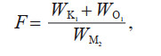 (6)
(6)where WK1, WO1, and WM2 are the major ellipse axes of the K1, O1, and M2 tidal constituents, respectively. When F≤0.5, the tide is a regular semidiurnal tide; when 0.5 < F≤2.0, the tide is an irregular semidiurnal tide; and when F>2.0, the tide is an irregular semidiurnal tide or regular diurnal tide depending on other circumstances. The pre- and post-reclamation values of F at the nine points are shown in Table 2. For most of the points, the value of F slightly increases after reclamation, but it is still ranges from 0.5 to 2. This indicates that the tidal type is hardly affected by land reclamation.
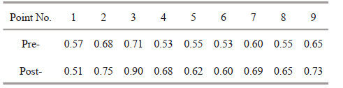
In particular, the M2 constituent is analysed because it is the dominant constituent and is a subject of widespread concern in the scientific community (Huang et al., 1999; Kang et al., 2002; Li et al., 2019). M2 can be characterized by the rotation rate (K) (shown in Table 3), which is defined as the ratio of the minor axis to the major axis of the tidal ellipse. A larger K value means that the constituent is closer to the rotating flow. When K is less than 0.25, the tide can be seen as reciprocating flow. The sign " - " in front of the value indicates a clockwise rotation.
The K values at most points decrease, which indicates that the tidal current around reclamation projects tends to be a reciprocating flow. Figures 9–10 show the tidal ellipse distribution throughout Bohai Bay and the changes at representative points around the projects. The ellipses in the coastal area become much more slender and are deflected synchronously after the reclamation projects, which is consistent with the decrease in K and the deflection of the current direction mentioned above. Specifically, the tidal current around Caofeidian widely changes to reciprocating flow after the project. The direction of the maximum velocity is approximately parallel to the breakwater or the coastline. However, around the Tianjin Binhai New Area, the minimum velocity of the M2 constituent decreases significantly after the reclamation project because of its perpendicular direction to the coastline and its limitation by the protruding structure. The tidal current around Huanghua Port exhibits both a minimum velocity decrease and a deflection of the tidal direction. In summary, the range of the reciprocating flow is extended. For the entire Bohai Bay, the impact of reclamation can reach the -8-m isobath.

|
| Fig.9 M2 tidal ellipses for the Bohai Bay in 2000 and 2015 The ellipses of the analysis points are highlighted with red line and bold black line for 2000 and 2015, respectively. |

|
| Fig.10 Comparison of tidal current ellipses at characteristic points in different years |
Tidal currents are the main causes of water environmental changes in coastal areas (Bárcena et al., 2012; Meyerjürgens et al., 2020; Niu et al., 2021). The reclamation projects along Bohai Bay have decreased the water exchange intensity due to tidal current changes (Yuan et al., 2015; Zhu et al., 2018b; Shang et al., 2019), which introduces potential risks to thermohaline diffusion, heavy metal migration, and nutrient distribution (Mu et al., 2017; Zhu et al., 2018a, b; Bai et al., 2019).
First, in the port or area adjacent to the reclamation project, the tidal current is significantly weakened, as shown in this research (Fig. 7). A consistent conclusion was reached by Wang et al. (2015), who believe that weakened hydrodynamics further decrease the water exchange capacity. Thermohaline diffusion and heavy metal migration are therefore restrained (Zhu et al., 2018a; Bai et al., 2019), which potentially increases the risk of water deterioration. On the southern and northern coasts of the Binhai New Area, the instantaneous current field indicates changes in the tidal current symmetry (Lin et al., 2015), as shown in Fig. 8. This figure implies that the seaward migration of the tidal current increases while landward migration decreases in these areas. Furthermore, these areas are distributed near the main estuaries in Bohai Bay, including the Ji' an River, Yongdingxin River, Ziyaxin River, and Duliujian River. These rivers are the main sources of heavy metals and nutrients from the land (Shan et al., 2016; Qi et al., 2020; Yu et al., 2021). The symmetry changes in the tidal current will slightly accelerate the diffusion of heavy metals and nutrients to the sea (Jia et al., 2018). These tidal symmetry changes can well explain the thermohaline diffusion predicted in previous studies. Water with high temperature and salinity levels tends to spread seawards rather than along the coastland because of the seaward current around the Binhai New Area (Bai et al., 2019). The diffusion rate is also accelerated in the southern coastal area of Huanghua Port (Bai et al., 2019), which is closely related to the extended flood tide duration found in this research. However, it should be noted that the pollutant concentration might be synthetically formed by multiple factors. The precise impacts of reclamation need further demonstrations and determinations (Mu et al., 2017).
In addition, the current direction also changes significantly in the coastal area, with more trends towards reciprocating flow (shown in Figs. 6 & 9). This finding can be demonstrated in investigations of water exchange due to reclamation in Bohai Bay, where the protruding coastline obstructs the current path along the coast and then extends the exchange time (Yuan et al., 2015). Consequently, the diffusion of pollutants along the coastline will likely be restrained. Both the diffusion rate and range will be limited (Bai et al., 2019). Notably, the water environment indicators have extremely complex interactions. In recent years, changes in the various indicators have shown various characteristics (Mu et al., 2017; Li et al., 2019). The flow discharge of the rivers has decreased for 80% since 1995 due to the upstream water transfer project and water resource utilization for industry and agriculture, which benefits the reduction of pollutants from the river into the bay (Zheng et al., 2007). Additionally, sediment flux is decreasing due to the large dams and reservoirs built along the rivers. The sediment has a high specific surface area and can easily adsorb aquatic substances such as nutrients and heavy metals (Li et al., 2018). Despite these factors, large amounts of urban, industrial and agricultural discharge are enriched in pollutants that empty into the bay through the rivers (Mu et al., 2017). For example, the Haihe River discharges approximately 800 000 Mt/d of effluent into Bohai Bay (Lü et al., 2007), increasing the pollutant concentrations in the estuary (Peng, 2015). Therefore, several national restoration programs, such as the "Bohai blue sea action plan", have been implemented to improve the ecosystem and have achieved some success (Mu et al., 2017). In summary, anthropogenic activity has become a major threat to the ecosystem of Bohai Bay and has changed its environment dramatically. More simulations and observations are needed to determine the fate of pollutants in Bohai Bay.
4.2 Cross-comparisons with other bays in ChinaRapid economic development in China' s coastal areas is accompanied by population growth and an increasing demand for land use. Large-scale land reclamation projects have been carried out in these coastal areas (Miao and Xue, 2021). Through cross-comparisons of different bays, we can find extensive impacts of reclamation projects. Although the sizes and types of the bays are different, reclamation projects commonly cause consistent hydrodynamic impacts. These impacts can provide references for the implementation of reclamation project and even the restoration of these areas in the bays. The most explicit impact of these projects is the reduction in water area, which weakens the tidal prism and energy flux into the bays (Wang et al., 2013; Yang and Chui, 2017; Deng et al., 2020). The reclamation projects on the tidal flats reshape the geomorphic form of the bays into one with a shallower water depth, leading to a slight decrease in the current velocity. According to existing studies, these circumstances have widely occurred in the bays of China, such as Meizhou Bay, Sanmen Bay, Deep Bay, Xiamen Bay, and Jiaozhou Bay (Wang et al., 2013; Gao et al., 2014; Xu et al., 2018; Yang and Chui, 2018; Deng et al., 2020). The changes in the flow field also alter the tidal current symmetry, which may weaken the water exchange and cause potential sediment deposition or water quality deterioration in most of the bays (Lou et al., 2009; Shi et al., 2011; Wang et al., 2013; Lin et al., 2015; Gao et al., 2018; Yang et al., 2019; Deng et al., 2020).
However, it should be noted that reclamation projects in different locations and of different types have distinct effects on the hydrodynamic environment and may even accelerate water exchange, such as the project in Deep Bay, which has different reclamation effects than those in Bohai Bay. In Deep Bay, the reclamation does not obstruct the water exchange channel but accelerates water circulation by narrowing the bay mouth and streamlining the coastline to strengthen the tidal effects on the water transport inside the bay. Consequently, the water exchange intensity increases with the significant reduction in the water age in the bay (Yang and Chui, 2017, 2018). It is also found that mariculture reclamation can retain the hydrodynamics to a certain extent, which results in less disturbance than direct land reclamation (Xu et al., 2018). For Bohai Bay, reclamation is mainly used for the construction of ports or erosion-resistant industrial areas. This type of reclamation occupies a large area of the ocean and serves as a barrier to water exchange (Yuan et al., 2015). In addition, the current velocity is unevenly distributed at the edges outside the breakwater against the sheltered water area due to structures (shown in Fig. 6). This poses a risk of sediment erosion or deposition. Therefore, more permeable structures should be used in future projects and the coastline should be optimized to a smoother shape to minimize the invasion to local hydrodynamics (Zhang et al., 2005; Iqbal et al., 2021). In conclusion, the types and locations of reclamation projects need to be further evaluated before their construction (Chu et al., 2022).
5 CONCLUSIONThe objectives of this paper are to investigate the reclamation-induced coastline changes and tidal current responses in Bohai Bay based on remote sensing images and numerical simulations. The responses of the most dominant constituent (M2) are also investigated through harmonic analysis. The conclusions are as follows.
The coastline of Bohai Bay continued to extend into the sea due to reclamation from 2000 to 2015. The reclamation rate first increased to 150.9 km2/a in 2005–2011 and then decreased to 56.5 km2/a in 2011–2015. The coastline length has correspondingly increased by more than 500 km since 2000.
After the reclamation projects, the tidal current field had been changed more unevenly near the project areas due to the construction masking and dike protrusion. The current velocity at peak flood and ebb tide had opposite variations in most nearshore areas, which indicated the evolution of tidal symmetry in the enhanced seaward movement. In addition, the tidal current tended to bypass the reclamation projects with deflected streamlines that were usually consistent with the coastline. The dominant M2 tidal constituent showed more characteristics of a reciprocating current with an expanded range to nearly the -8-m isobath in the bay.
Reclamation-induced tidal current changes introduce the potential risks of water environmental deterioration and sediment erosion or deposition. An optimal utilization of permeable structures and smooth coastline shapes should be considered in future reclamation projects.
6 DATA AVAILABILITY STATEMENTAll data generated and/or analyzed during this study are available on request.
Bai Y C, Wen Z C, Xu H J. 2019. Simulation the response and predict the effect of concentrated-heated brine discharged into the Bohai Bay under reclamation condition. Haiyang Xuebao, 41(3): 62-75.
(in Chinese with English abstract) DOI:10.3969/j.issn.0253-4193.2019.03.008 |
Bárcena J F, García A, Gómez A G, et al. 2012. Spatial and temporal flushing time approach in estuaries influenced by river and tide. An application in Suances Estuary (Northern Spain). Estuarine, Coastal and Shelf Science, 112: 40-51.
DOI:10.1016/j.ecss.2011.08.013 |
Cao W T, Zhou Y Y, Li R, et al. 2020. Mapping changes in coastlines and tidal flats in developing islands using the full time series of Landsat images. Remote Sensing of Environment, 239: 111665.
DOI:10.1016/j.rse.2020.111665 |
Chu N Y, Yao P, Ou S Y, et al. 2022. Response of tidal dynamics to successive land reclamation in the Lingding Bay over the last century. Coastal Engineering, 173: 104095.
DOI:10.1016/j.coastaleng.2022.104095 |
Deng G F, Shen Y M, Li C P, et al. 2020. Computational investigation on hydrodynamic and sediment transport responses influenced by reclamation projects in the Meizhou Bay, China. Frontiers of Earth Science, 14(3): 493-511.
DOI:10.1007/s11707-019-0758-8 |
Ding X S, Shan X J, Chen Y L, et al. 2019. Dynamics of shoreline and land reclamation from 1985 to 2015 in the Bohai Sea, China. Journal of Geographical Sciences, 29(12): 2031-2046.
DOI:10.1007/s11442-019-1703-1 |
Ding Y M, Wei H. 2017. Modeling the impact of land reclamation on storm surges in Bohai Sea, China. Natural Hazards, 85(1): 559-573.
DOI:10.1007/s11069-016-2586-4 |
Feng L, Zhu X D, Sun X. 2014. Assessing coastal reclamation suitability based on a fuzzy-AHP comprehensive evaluation framework: a case study of Lianyungang, China. Marine Pollution Bulletin, 89(1-2): 102-111.
DOI:10.1016/j.marpolbul.2014.10.029 |
Gao G D, Wang X H, Bao X W, et al. 2018. The impacts of land reclamation on suspended-sediment dynamics in Jiaozhou Bay, Qingdao, China. Estuarine, Coastal and Shelf Science, 206: 61-75.
DOI:10.1016/j.ecss.2017.01.012 |
Gao G D, Wang X H, Bao X W. 2014. Land reclamation and its impact on tidal dynamics in Jiaozhou Bay, Qingdao, China. Estuarine, Coastal and Shelf Science, 151: 285-294.
DOI:10.1016/j.ecss.2014.07.017 |
Hou Q Z, Lu Y J, Wang Z L. 2017. Cumulative impacts of high intensity reclamation in Bohai Bay on tidal wave system and its mechanism. Chinese Science Bulletin, 62(30): 3479-3489.
(in Chinese with English abstract) DOI:10.1360/N972017-00468 |
Hu C, You Z J, Mao H Y, et al. 2018. Assessing impacts of large-scale Coastal land reclamation on marine environment on the coast of China. Journal of Coastal Research, 85: 1486-1490.
DOI:10.2112/SI85-298.1 |
Huang D J, Su J L, Backhaus J O. 1999. Modelling the seasonal thermal stratification and baroclinic circulation in the Bohai Sea. Continental Shelf Research, 19(11): 1485-1505.
DOI:10.1016/S0278-4343(99)00026-6 |
Iqbal M, Widyaningtias, Wiyono A, et al. 2021. Effect of permeable structure on coastal sediment transport in Demak Regency, Central Java, Indonesia Model by using Delft3D software. IOP Conference Series: Earth and Environmental Science, 698(1): 012040.
DOI:10.1088/1755-1315/698/1/012040 |
Jia H, Shen Y M, Su M R, et al. 2018. Numerical simulation of hydrodynamic and water quality effects of shoreline changes in Bohai Bay. Frontiers of Earth Science, 12(3): 625-639.
DOI:10.1007/s11707-018-0688-x |
Jiang S H, Hu R J, Feng X L, et al. 2018. Influence of the construction of the Yantai West Port on the dynamic sedimentary environment. Marine Georesources & Geotechnology, 36(1): 43-51.
DOI:10.1080/1064119X.2017.1278809 |
Kang S K, Foreman M G G, Lie H J, et al. 2002. Two-layer tidal modeling of the Yellow and East China Seas with application to seasonal variability of the M2 tide. Journal of Geophysical Research: Oceans, 107(C3): 3020.
DOI:10.1029/2001JC000838 |
Kang S K, Jung K T, Kim E J, et al. 2013. Tidal regime change due to the large scale of reclamation in the west coast of the Korean Peninsula in the Yellow and East China Seas. Journal of Coastal Research, 65: 254-259.
DOI:10.2112/SI65-044.1 |
Kuang C P, Huang J, Lee J, et al. 2013. Impact of large-scale reclamation on hydrodynamics and flushing in Victoria Harbour, Hong Kong. Journal of Coastal Research, 29(6): 128-143.
DOI:10.2112/JCOASTRES-D-11-00153.1 |
Kuang C P, Mao X D, Liu P C, et al. 2015. Influence of wind force on a silt-muddy coast: Huanghua Harbor Coast, China. Journal of Waterway, Port, Coastal, and Ocean Engineering, 141(6): 05015001.
DOI:10.1061/(ASCE)WW.1943-5460.0000299 |
Li H J, Gao X L, Gu Y B, et al. 2018. Comprehensive large-scale investigation and assessment of trace metal in the coastal sediments of Bohai Sea. Marine Pollution Bulletin, 129(1): 126-134.
DOI:10.1016/j.marpolbul.2018.02.022 |
Li M G, Zheng J Y. 2007. Introduction to Chinatide software for tide prediction in China seas. Journal of Waterway and Harbor, 28(1): 65-68.
(in Chinese with English abstract) DOI:10.3969/j.issn.1005-8443.2007.01.015 |
Li Y Y, Feng H, Yuan D K, et al. 2019. Mechanism study of transport and distributions of trace metals in the Bohai Bay, China. China Ocean Engineering, 33(1): 73-85.
DOI:10.1007/s13344-019-0008-6 |
Liang H D, Kuang C P, Olabarrieta M, et al. 2018. Morphodynamic responses of Caofeidian channel-shoal system to sequential large-scale land reclamation. Continental Shelf Research, 165: 12-25.
DOI:10.1016/j.csr.2018.06.004 |
Lin L, Liu Z, Xie L, et al. 2015. Dynamics governing the response of tidal current along the mouth of Jiaozhou Bay to land reclamation. Journal of Geophysical Research: Oceans, 120(4): 2958-2972.
DOI:10.1002/2014JC010434 |
Lou A G, Hu Y B, Kuang L, et al. 2009. Analysis and prediction of influence imposed on Jiaozhou Bay tidal currents and tidal energy of M2 tidal system by Jiaozhou Bay reclamation. Journal of Ocean University of China, 8(1): 23-29.
DOI:10.1007/s11802-009-0023-y |
Lü J X, Wang Y W, Zhang Q H, et al. 2007. Contamination trends of polybrominated diphenyl ethers, organochlorine pesticides and heavy metals in sediments from Dagu Drainage River estuary, Tianjin. Chinese Science Bulletin, 52(10): 1327-1337.
DOI:10.1007/s11434-007-0202-4 |
Lu Y J, Ji R Y, Zuo L Q. 2009. Morphodynamic responses to the deep water harbor development in the Caofeidian sea area, China's Bohai Bay. Coastal Engineering, 56(8): 831-843.
DOI:10.1016/j.coastaleng.2009.02.005 |
Manda A, Matsuoka K. 2006. Changes in tidal currents in the ariake sound due to reclamation. Estuaries and Coasts, 29(4): 645-652.
DOI:10.1007/BF02784289 |
Meyerjürgens J, Ricker M, Schakau V, et al. 2020. Relative dispersion of surface drifters in the North Sea: the Effect of tides on mesoscale diffusivity. Journal of Geophysical Research: Oceans, 125(8): e2019JC015925.
DOI:10.1029/2019JC015925 |
Miao D D, Xue Z H. 2021. The current developments and impact of land reclamation control in China. Marine Policy, 134: 104782.
DOI:10.1016/j.marpol.2021.104782 |
Mu D, Yuan D K, Feng H, et al. 2017. Nutrient fluxes across sediment-water interface in Bohai Bay Coastal Zone, China. Marine Pollution Bulletin, 114(2): 705-714.
DOI:10.1016/j.marpolbul.2016.10.056 |
Niu L X, Luo X X, Cai H Y, et al. 2021. Seasonal dynamics of polycyclic aromatic hydrocarbons between water and sediment in a tide-dominated estuary and ecological risks for estuary management. Marine Pollution Bulletin, 162: 111831.
DOI:10.1016/j.marpolbul.2020.111831 |
Peng S T. 2015. The nutrient, total petroleum hydrocarbon and heavy metal contents in the seawater of Bohai Bay, China: temporal-spatial variations, sources, pollution statuses, and ecological risks. Marine Pollution Bulletin, 95(1): 445-451.
DOI:10.1016/j.marpolbul.2015.03.032 |
Qi Y J, Liu X, Wang Z, et al. 2020. Comparison of receptor models for source identification of organophosphate esters in major inflow rivers to the Bohai Sea, China. Environmental Pollution, 265: 114970.
DOI:10.1016/j.envpol.2020.114970 |
Shan B Q, Li J, Zhang W Q, et al. 2016. Characteristics of phosphorus components in the sediments of main rivers into the Bohai Sea. Ecological Engineering, 97: 426-433.
DOI:10.1016/j.ecoleng.2016.10.042 |
Shang J C, Sun J, Tao L, et al. 2019. Combined effect of tides and wind on water exchange in a semi-enclosed shallow sea. Water, 11(9): 1762.
DOI:10.3390/w11091762 |
Shi J H, Li G X, Wang P. 2011. Anthropogenic influences on the tidal prism and water exchanges in Jiaozhou Bay, Qingdao, China. Journal of Coastal Research, 27(1): 57-72.
DOI:10.2112/JCOASTRES-D-09-00011.1 |
Song D H, Wang X H, Cao Z Y, et al. 2013. Suspended sediment transport in the deepwater navigation channel, Yangtze River Estuary, China, in the dry season 2009: 1. Observations over spring and neap tidal cycles. Journal of Geophysical Research: Oceans, 118(10): 5555-5567.
DOI:10.1002/jgrc.20410 |
Song D H, Wang X H. 2013. Suspended sediment transport in the deepwater navigation channel, Yangtze River Estuary, China, in the dry season 2009: 2. Numerical simulations. Journal of Geophysical Research: Oceans, 118(10): 5568-5590.
DOI:10.1002/jgrc.20411 |
Suh S W, Lee H Y, Kim H J. 2014. Spatio-temporal variability of tidal asymmetry due to multiple coastal constructions along the west coast of Korea. Estuarine, Coastal and Shelf Science, 151: 336-346.
DOI:10.1016/j.ecss.2014.09.007 |
Sun J, Tao J H. 2006. Relation matrix of water exchange for sea bays and its application. China Ocean Engineering, 20(4): 529-544.
DOI:10.3321/j.issn:0890-5487.2006.04.002 |
Tian B, Wu W T, Yang Z Q, et al. 2016. Drivers, trends, and potential impacts of long-term coastal reclamation in China from 1985 to 2010. Estuarine, Coastal and Shelf Science, 170: 83-90.
DOI:10.1016/j.ecss.2016.01.006 |
Wang F, Tian L Z, Jiang X Y, et al. 2018. Human-induced changes in recent sedimentation rates in Bohai Bay, China: implications for coastal development. Science China Earth Sciences, 61(10): 1510-1522.
DOI:10.1007/s11430-017-9237-4 |
Wang J, Hong H S, Zhou L M, et al. 2013. Numerical modeling of hydrodynamic changes due to coastal reclamation projects in Xiamen Bay, China. Chinese Journal of Oceanology and Limnology, 31(2): 334-344.
DOI:10.1007/s00343-013-2109-z |
Wang W Z, Dong L J. 2007. Basic characteristics of flow field in Bohai Sea by Mike 21 simulation. Yellow River, (10): 32-33.
(in Chinese) DOI:10.3969/j.issn.1000-1379.2007.10.014 |
Wang Y Z, Wu D, Shi H H, et al. 2015. Impact of reclamation on water exchange in Bohai Bay in recent decade. Oceanologia et Limnologia Sinica, 46(3): 471-480.
(in Chinese with English abstract) DOI:10.11693/hyhz20140700194 |
Xu F, Tao J F, Zhou Z, et al. 2016. Mechanisms underlying the regional morphological differences between the northern and southern radial sand ridges along the Jiangsu Coast, China. Marine Geology, 371: 1-17.
DOI:10.1016/j.margeo.2015.10.019 |
Xu H J, Huang Z, Bai Y C, et al. 2020a. Numerical analysis of sediment deposition in Yangtze River Estuary: Insight from conceptual estuary models. Applied Ocean Research, 104: 102372.
DOI:10.1016/j.apor.2020.102372 |
Xu H J, Huang Z, Bai Y, et al. 2020b. Effects of flow circulations on the sediment dynamics in the deep-water navigation channel of the Yangtze River estuary. Journal of Coastal Research, 95(sp1): 723a-727a.
DOI:10.2112/SI95-141.1 |
Xu X F, He Q Q, Song D, et al. 2018. Comparison of hydrodynamic influence between different types of bay reclamations. Journal of Hydrodynamics, 30(4): 694-700.
DOI:10.1007/s42241-018-0075-9 |
Xu Y D, Gao H W, Wei X, et al. 2021. The effects of reclamation activity and Yellow River runoff on coastline and area of the Laizhou Bay, China. Journal of Ocean University of China, 20(3): 729-739.
DOI:10.1007/s11802-021-4746-8 |
Yang W K, Feng X R, Yin B S. 2019. The impact of coastal reclamation on tidal and storm surge level in Sanmen Bay, China. Journal of Oceanology and Limnology, 37(6): 1971-1982.
DOI:10.1007/s00343-019-8247-1 |
Yang Y, Chui T F M. 2017. Hydrodynamic and transport responses to land reclamation in different areas of semi-enclosed subtropical bay. Continental Shelf Research, 143: 54-66.
DOI:10.1016/j.csr.2017.06.008 |
Yang Y, Chui T F M. 2018. Combined ecohydrological effects of wind regime change and land reclamation on a tidal marsh in semi-enclosed bay. Ecological Engineering, 124: 123-134.
DOI:10.1016/j.ecoleng.2018.09.026 |
Yu J, Bao X W, Ding Y, et al. 2016. The impact of large-scale reclamation on hydro-dynamic environment - a case study of Xinghua Bay. Journal of Ocean University of China, 15(4): 583-592.
DOI:10.1007/s11802-016-2911-2 |
Yu J, Zhang W, Tan Y, et al. 2021. Dual-isotope-based source apportionment of nitrate in 30 rivers draining into the Bohai Sea, North China. Environmental Pollution, 283: 117112.
DOI:10.1016/j.envpol.2021.117112 |
Yuan D K, Li G, Wang D S, et al. 2015. Numerical simulation of effects of land reclamation on water exchange capability of Bohai Bay. Journal of Tianjin University (Science and Technology), 48(7): 605-613.
(in Chinese with English abstract) DOI:10.11784/tdxbz201312095 |
Zhang W, Li Y T, Wang X Y, et al. 2005. Experimental study on deposition promotion of permeable structure. Journal of Sichuan University (Engineering Science Edition), 37(6): 31-37.
(in Chinese with English abstract) DOI:10.15961/j.jsuese.2005.06.00 |
Zheng B H, Qin Y W, Meng W, et al. 2007. Historical evolvement trends of nutrients in waters of Bohai Bay from 1985 to 2003. Environmental Science, 28(3): 494-499.
(in Chinese with English abstract) DOI:10.13227/j.hjkx.2007.03.009 |
Zhu G R, Xie Z L, Li T Y, et al. 2017a. Assessment ecological risk of heavy metal caused by high-intensity land reclamation in Bohai Bay, China. PLoS One, 12(4): e0175627.
DOI:10.1371/journal.pone.0175627 |
Zhu G R, Xu X G, Wang H, et al. 2017b. The ecological cost of land reclamation and its enlightenment to coast sustainable development in the northwestern Bohai Bay, China. Acta Oceanologica Sinica, 36(4): 97-104.
DOI:10.1007/s13131-017-1016-0 |
Zhu H, Bing H J, Yi H P, et al. 2018a. Spatial distribution and contamination assessment of heavy metals in surface sediments of the Caofeidian adjacent sea after the land reclamation, Bohai Bay. Journal of Chemistry, 108(108): 1-13.
DOI:10.1155/2018/2049353 |
Zhu L H, Hu R J, Zhu H J, et al. 2018b. Modeling studies of tidal dynamics and the associated responses to coastline changes in the Bohai Sea, China. Ocean Dynamics, 68(12): 1625-1648.
DOI:10.1007/s10236-018-1212-2 |