 2023, Vol. 41
Institute of Oceanology, Chinese Academy of Sciences
Article Information
- LI Ping, JIN Yongde, GAO Wei, ZHAO Xiaolong
- Spatial differentiation and dynamic mechanism of microgeomorphology based on acoustic spectrum data of the Huanghe (Yellow) River Delta
- Journal of Oceanology and Limnology, 41(6): 2077-2089
- http://dx.doi.org/10.1007/s00343-022-2280-1
Article History
- Received Jul. 31, 2022
- accepted in principle Sep. 13, 2022
- accepted for publication Oct. 28, 2022


2 Key Laboratory of Coastal Science and Integrated Management of Oceanography, Ministry of Natural Resources, Qingdao 266061, China
In history, the Huanghe (Yellow) River has often breached and has needed diverting and dredging every 100 years. In more than 2 500 years since the pre-Qin dynasty in China, there have been more than 1 500 floods and 26 diversions downstream of the Huanghe River (Yang et al., 2020), covering areas reaching Tianjin to the north and Jianghuai region to the south. The Huanghe River is characterized by a low water to sediment ratio and an inconsistent relationship between the water and sediment. Additionally, since the Huanghe River moved northward and changed its channel to the sea from the Bohai Sea in 1855; the old channels of the Huanghe River have frequently diverted and changed, forming a complex accumulation body with multistage, overlapping sub-delta lobes and the complex sedimentary dynamic environment of the Huanghe River delta (HRD). Then, during the period from 1855 to 1938, the Huanghe River changed its channel in seven stages with Ninghai as its vertex, forming the first generation of the delta. Subsequently, from 1953 to 1988, the swing vertex of the old channels in the lower reaches moved down to Yuwa, forming the second generation of the delta. The delta was mainly composed of the Diaohe, Shenxiangou, and Qingshuigou Rivers at that time. The third generation of the HRD included the Qingshuigou and Diaohe River outlet channel deltas.
The modern HRD is a complex and unified land-sub-tidal deposit geomorphologic system composed of alluvial plains in the upper section of the delta, alluvial-marine plains in the lower part, and surrounding tidal flats (Yang et al., 1990; Chen et al., 1992; Cui and Yin, 1994). Submarine micro-geomorphology is a geomorphologic type known to occur in the shallow and surface layers of the seabed that has been identified through interpretations of acoustic data obtained by survey methods such as high-resolution multi-beam sounding, side-scan sonar processes, and sub-bottom profiling. The combined relationships and distribution trends of the micro-geomorphology indirectly reflect the coupling relationships among the sediment deposition, dynamic environments, and geomorphologic evolution in local areas. Under the environmental conditions created by the frequent diversions of old channels in the lower reaches of the Huanghe River and the overlapping of sub-delta lobes, the superposition coupling of seabed scouring and silting dynamics, sediment distributions, sediment supply and diffusion, and hydrodynamic conditions has resulted in the formation of new micro-geomorphologic patterns characterized by a dynamic evolution over time and regional spatial differentiation. This included the breach and channel invasion of the Daqing River into the Huanghe River at Lankao Dongbatou town in 1855 (Cui and Yin, 1994).
The sub-aerial delta geomorphology of the Huanghe River includes delta alluvial plains, pro-delta alluvial plains, and surrounding tidal flats. The submerged delta geomorphology includes offshore slopes and shelf accumulation plains. The offshore slopes can be divided into erosion-submerged delta slopes, erosion-accumulation-submerged delta slopes, and other sub-geomorphologic types. The coastal waters of the HRD can be divided into various geomorphologic types, such as offshore shoals, offshore slopes, submerged deltas, tidal deltas, submarine sand waves, and tidal ridges. On the inner shelves, the main geomorphologic types include shore face terraces, ancient coastlines, ancient channels, and pit-and-pot. On the outer shelf, the geomorphologic types include shelf plains, paleo-shoals, paleo-deltas, shallow troughs, sand waves, sand dunes, buried ancient channels, submarine slides, and other residual landforms, as detailed in Fig. 1. Having been affected by continuous marine dynamic erosion and accumulation transformations, the geomorphic types have evolved in a sequence of shallow seas, pro-deltas, delta fronts, river-mouth bars, fluvial highlands, and marine cliff ridges. Sloping and undulating submerged delta fronts have evolved into submerged delta slopes with gently sloping gradients.

|
| Fig.1 Huanghe (Yellow) river basin map (a) and distribution of various geo-morphological types in the modern HRD region (b) LYX: Longyangxia; LJX: Liujiaxia; SMX: Sanmanxia; XLD: Xiaolangdi; TNH: Tangnaihai; LZ: Lanzhou; TDG: Toudaoguai; LM: Longmen; HYK: Huayuankou; LJ: Lijin. |
In the present study, the structure and tectonics of the shallow strata were continuously detected using a sub-bottom profiler based on the principles of hydro-acoustics. The surface geomorphologic characteristics of the seabed were detected using a side-scan sonar method based on the principle of echo depth sounding. The combination of these two methods allowed for the identification of submarine shallow micro-geomorphologic types, as well as their scale and spatial distributions. Therefore, based on the data blind zones in complex shallow water areas, simultaneous arrival of echoes from different directions, and large interference and low resolution of coarse-grained, hard submarine acoustic sequences, and the types and characteristics of the submarine shallow surface micro-geomorphology were interpreted by analyzing the reflection characteristics of the wide-range, full-coverage, high-resolution sub-bottom profiles, and the side-scan sonar acoustic profiles. Changes in river system are important factors affecting the evolution of offshore sedimentary environments (Jiang et al., 2017; Ji et al., 2018; Yang et al., 2020), and the grain size of delivered sediments and river inputs play the dominant roles in stepwise morphological evolution (Walling and Fang, 2003; Yu et al., 2011; Fagherazzi et al., 2015; Wu et al., 2017). In this study, based on an analysis of the relationships among the sedimentation, dynamics, and geomorphology in the coastal waters of the HRD, the micro-geomorphologic characteristics, spatial differentiation, and dynamic mechanisms of the HRD were examined. In addition, the mechanisms of the main influencing factors on the formation and development of the micro-geomorphology, such as the variations in water and sediment, seabed scouring and silting, hydrodynamic conditions, and sediment types, were also discussed. The findings of this investigation help clarify the relationships between sediment deposition in the Huanghe River estuary and the evolution of the delta and provide a scientific basis for resource protection and ecological restoration in the HRD region.
2 MATERIAL AND METHODIn the present study, the spatial distribution, regional difference, and dynamic influencing factors of micro-geomorphology in the subaqueous delta of the Huanghe River were analyzed based on the measured data of shallow stratum profile and side-scan sonar. In recent years, the wide application of high-resolution sub-bottom profiling technology has made it faster and more convenient to obtain large-scale, high-precision, and high-density shallow profile data in coastal waters. This technology has also provided the possibility to discover buried ancient river channels and track and determine the swings and changes in the old channels in the lower reaches of the Huanghe River over certain historical periods. The "correspondence" between the ancient river channels at different buried levels and the flow paths in the lower reaches of the Huanghe River over different periods has now been established.
The micro-geomorphologic types were identified according to the reflections of acoustic profiles and the characteristics of sequence strata using the interpretations of the wide-range side-scan sonar and shallow stratigraphic profile data from the HRD. As a result, the scale and range of the micro-geomorphologic types were clarified. Effective data were available from the sub-bottom profiles and side-scan sonar acoustic profiles, which covered a wide range (3 200 km2) of the sub-delta lobe deposits during different stages since 1855 (Fig. 2). The data obtained from 2 400-km shallow profile and side-scan sonar data in 5-m deep sea area along the HRD in the National 908 special QC07 block. In 2012 and 2013, 310 km and 240 km, respectively, were recorded for special exploration activities carried out by the state marine public welfare industry, the data obtained from the exploration of 20 lines and wells in the Chengdao sea area where is mainly producing area of oil in the north of the HRD is about 250 km. The sub-bottom profiles were collected using a CSP2200 high-resolution mid-stratum profiler, which was produced by Applied Acoustic Engineering (AAE, UK). The exploration data map was found to be clear, and the acoustic impedance interfaces could be clearly identified in the events and were continuous in phase. In addition, an EdgTech 4200-FS dual-frequency and all-digital side-scan sonar system (EdgTech Co., USA) was used for side-scan sonar acquisition. This system integrated full-spectrum and multi-pulse exploration technology, which increased the number of suitable data records in high- and low-frequency channels that had a high signal-to-noise ratio. The Triton interpretation and analysis software had the seabed tracking, slant-range correction, TVG and AGC enhancement, and target capture functions. This software was able to interpret and extract characteristic parameters of the micro-geomorphology via human-computer interactions.

|
| Fig.2 Distributions of the sub-bottom profilers and side-scan acoustic sonars |
According to the section morphology of the sub-bottom profile acoustic profiles, the filling and sedimentary characteristics, and the amplitude, frequency, phase, continuity, and wave group combination relationships of the reflected waves in the sub-bottom profile acoustic stratigraphic sequences, the acoustic impedance reflection interfaces were interpreted, and then the acoustic reflection interface was divided (Li and Du, 2011), to identify and delineate the submarine micro-geomorphology. Based on the continuity characteristics of the grayscale, waveform, and sequence amplitude of the high-resolution side-scan sonar acoustic profiles, and the micro-geomorphologic types were interpreted by means of different directions, multiple records, and various comparisons. The type, regional location, scale, and range of the micro-geomorphology were identified by reducing the micro-geomorphologic characteristic parameters based on the shadow height differences and slant ranges of the reflector. The spatial combination relationships of the submarine micro-geomorphologic types and the dynamic mechanisms of their formations and development were discussed in this study, along with the changes in the regional dynamic conditions, sedimentary environment, seabed sediment, and seabed scouring and silting.
3 RESULTThis study determined that, due to the regional differences in the dynamic sedimentary conditions of the delta, the micro-geomorphology in the HRD differed in the number of types, scale and scope, and genetic mechanisms, which reflected the spatial differentiation of the coupled regional micro-geomorphologic environmental factors. In previous related studies, researchers developed zoning methods for the local small-scale sedimentary environments of the HRD with different index parameters. They found that the sedimentary zoning and corresponding dynamic mechanisms of the HRD could be studied using the regional water depth conditions, sedimentary characteristics, and characteristics of scale and range indices (Zhou et al., 2004; Zhao et al., 2006). For example, according to the types, scales, and main influencing factors of the micro-geomorphology, the HRD was divided into the Diaohe River sub-delta lobe, wave-dominated erosion micro-geomorphologic zone, Shenxiangou lobe sub-delta water flow hydrodynamic coupling multiple micro-geomorphologic type distribution zone, current estuary river-dominated accumulation micro-geomorphologic zone, deep-water area single micro-geomorphologic type distribution zone, and Chengdao sea area potential micro-geomorphologic type development zone.
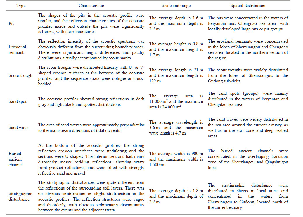
Through the interpretation of survey data such as sub-bottom profiles and side-scan sonar results, this study found that the relationships between the micro-geomorphologic features and spatial combinations could be further clarified, which is important for research on micro-geomorphologic features and their dynamic mechanisms (Li et al., 2002). Interpretations of the wide-range sub-bottom profiles and side-scan sonar acoustic profiles indicated that the formation and development of the micro-geomorphology in the HRD were the results of the superposition of the coupling of seabed sediment, hydrodynamic force, seabed scouring and silting, and sediment supply. For example, seven typical types of micro-geomorphology were identified in the HRD. These included pits, erosional remnants, sand spots, sand waves, scour troughs, buried ancient channels, and stratigraphic disturbances. In accordance with the occurrence of these locations, the region was divided into shallow stratigraphic micro-geomorphology (buried ancient channels and stratigraphic disturbances) and submarine surface micro-geomorphology (pits, erosion remnants, sand spots, sand waves, and scour troughs) types (Table 1). The genetic mechanism can be inferred from the characteristics of the micro-geomorphology types. The shape of the pits is the result of the interaction between dynamic wave flow and seabottom sediments, which reflects the difference of the sediments: in the coarse-grained and hard submarine acoustic sequences, sand spots were formed by uneven scouring of the bottom current; sand waves were formed by the interactions of waves and currents and the directions were controlled by the dynamic conditions of stronger waves and the reciprocating flow. The HRD is inlaid in strips on the outer edge of the delta front slopes and and is characterized by geomorphologic types that include front uplifts, underwater channels, acoustic transparent layers, and smooth deltas. From the perspective of acoustic data interpretations, the scale, range, and spatial locations of the micro-geomorphology in the HRD revealed seasonal variation characteristics, and the spatial distributions displayed significant regional differentiation characteristics. In the overlapping sub-delta transition zone of Shenxiangou and Qingshuigou and in the sub-delta lobes of the Diaohe River, pits, erosional remnants, and scour troughs were widely distributed. The micro-geomorphologic types of stratigraphic disturbances and buried ancient channels represent the stability levels of the seabed and the diversions in the lower reaches, respectively. In addition, strong stratigraphic disturbances and areas with densely distributed buried ancient channels reflected the activity and instability of the submarine shallow strata (Fig. 3).
|

|
| Fig.3 Acoustic profile and spatial combination distributions of erosion micro-geomorphologic types and buried ancient river channels in the shallow coastal and surface layers of the Huanghe River delta |
The erosion micro-geomorphologic types, including buried ancient channels, erosional remnants, and pits (groups), are known to be directly related in genesis to the abandonment, diversion, and sediment supply changes in the lower reaches. Furthermore, from the perspective of the combined relationships of the micro-geomorphologic types and their influencing factors, the spatial combination differentiations of the different micro-geomorphologic types displayed certain regularities. For example, the stratigraphic disturbances and sand spot micro-geomorphology types were accompanied by silt and sandy sediment, respectively, and their distribution ranges were found to be highly consistent. Additionally, the sand spot and stratigraphic disturbance micro-geomorphology types displayed significant correlations with the distribution ranges of silt and were mainly distributed in the coastal waters of Gudong and Feiyantan, respectively. The sand wave micro-geomorphology type was found to be widely distributed in the area around the current estuary where the sediment supply was sufficient. The dynamic conditions of wave flow were observed to be complex and seabed scouring and silting drastically changed.
Based on the sub-bottom profile data covering a wide range (3 200 km2) of the coastal waters of the HRD, section morphology of the acoustic profiles of sub-bottom profiles, and the filling and sedimentary characteristics of the fluvial sand, the buried ancient river channels were delineated, identified, and confirmed. The spatial locations, buried horizons, and scale ranges were then quantified, and the formation ages were determined by combining the geological drilling and paleo-environmental information. The sedimentary environmental conditions were determined using the change maps of the distributaries channels, topographic maps of the different periods, and bathymetric charts of the sea areas. Then, the material sources could be traced, and the distributaries channels providing the sediment were identified. The active ages of the distributaries channels were essentially the ages of the sediment layers (Zhao et al., 2014). In the present study, based on research on the sub-bottom profiles, the buried ancient river channels in the shallow strata and flow paths in the lower reaches of the Huanghe River were determined for a certain historical period. In addition, through the interpretation of the sub-bottom profile detection data, the diversion processes of the flow paths in the lower reaches of the Huanghe River were obtained for a certain historical period in the coastal waters of the HRD. As indicated by the interpretation of the sub-bottom profile data, twenty effective points were identified for the locations of buried ancient river channels, and three flow paths of the Huanghe River in three different periods were reconstructed. These three flow paths were determined to be the current flow paths of the Huanghe River during different development stages (Li et al., 2013, 2014). Among these three flow paths in the lower reaches of the Huanghe River, two paths were in the NE direction and one was in the E direction. The results of this investigation of the flow paths in the lower reaches of the Huanghe River based on the detection of sub-bottom profiles were consistent with the current trend of the diversion processes of the flow paths in the lower reaches of the Huanghe River. Therefore, the findings reflected generally the diversion processes of the flow paths in the lower reaches of the modern HRD.
4 DISCUSSIONThe coupling and superposition of influencing factors, such as the sediment supply of the Huanghe River, changes in the dynamic conditions of the delta, scouring and silting characteristics of the seabed, and distribution of the seabed sediment, determined the spatial combinations and distributions of the submarine micro-geomorphologic types. In addition, the amount of supplied sediment and the hydrodynamic conditions determined the scope and range of the micro-geomorphology. Meanwhile, the diversions of old channels in the lower reaches and the overlapping succession of the sub-delta lobes affected the spatial differentiation and development of the micro-geomorphology and reflected the dynamic changes in the scouring and silting of the seabed and the spatial differences within the sedimentary environment.
4.1 Sediment supply and hydrodynamic conditions determining the spatial distribution patterns of the micro-geomorphology in the Huanghe RiverFrom the perspective of the material sources and dynamic conditions required for the formation and development of micro-geomorphology, the sediment and hydrodynamic conditions of the Huanghe River were found to determine the types (erosion or siltation), spatial distributions, scales and ranges of the micro-geomorphology. In the present study, significant spatial distribution differences were observed in the type, scale, and range of the micro-geomorphology of the sub-delta lobe sediment during the different development stages. Figure 4 shows the annual runoff and sediment discharge process curves at Lijin Station for the period ranging from 1950 to 2016, which reflected significant inter-annual variations in runoff and sediment flux. The variation of sediment into the sea has an important influence on the distribution of micro-geomorphology. These dimentary micro-geomorphology is the main type when the sediment supply is sufficient, while the erosive micro-geomorphology is mainly developed in the north of the delta where the sediment supply is less. With the decrease of water and sediment in the river, the distribution range of silting micro-geomorphology is gradually reduced, and the scale is in a decreasing trend. In recent years, significant fluctuations have been recorded, with significant reduction or even cessation of runoff and sediment (Wang et al., 2007; Miao et al., 2011; Tian et al., 2016; Jiang et al., 2017).

|
| Fig.4 Inter-annual variations in the annual sediment discharge and runoff of the Huanghe River into the sea |
The sub-delta lobes were also found to overlap during the different development stages. There were very large differences found in the amount of sediment supply and erosion or siltation between the current sub-delta and the abandoned sub-delta of the Huanghe River estuary. The sub-delta slopes with near-shore erosion were in a period of rapid and unstable erosion. With the diversion of the old channels in the lower reaches of the Huanghe River, the sediment supply of the Huanghe River transported into the sea was continuously reduced or even cut off. As a result, marine dynamic conditions were significantly enhanced and changed from river action to marine power. In the sub-delta lobe slopes of the Diaohe River (abandoned old estuary), which had been diverted northward from the HRD, erosion micro-geomorphologic types with different degrees of erosion (such as pit groups, sand spots, erosional remnants, and erosion grooves) were widely developed. From the viewpoint of the diffusion/transport paths and scope of the sediment from the Huanghe River into the sea, sediment diffusion from the Huanghe River into the sea was concentrated only in the sea areas around the estuary, and the northern boundary of estuary sediment diffusion was located at the northern end of the Gudong sea area. The sand waves were concentrated in the accumulation micro-geomorphologic types in the area adjacent to the existing estuary. However, with increasing offshore distance, the number of submarine erosion micro-geomorphologic types and their scales increased accordingly (Li et al., 2010; Xing et al., 2016).
At the front edge of the current estuary sub-delta lobes, the tidal currents and river dynamics stabilized and weakened. The former undulated and inclined submerged delta fronts developed and transformed into submerged delta slopes with smaller slope gradients, which then formed and developed into micro-geomorphologic types such as erosional remnants and sand spots. An arc-shaped, high-velocity zone consistently existed around the current estuarine spit, and a NE-trending, arc-shaped tidal shear frontal zone existed around the current estuary. In addition, waves and river flow played strong roles in the coastal geomorphology of the abandoned estuary, and the dynamic force within the current estuary weakened (Chu et al., 2006; Fan et al., 2018; Dong et al., 2019). With the seaward expansion of the estuarine spit, the high-velocity zone moved southeast, and the range and velocity continuously increased. The maximum wavelength of the sand waves that had developed within 50 km of the current estuary was 13.4 m. Additionally, the types and scales of the submarine micro-geomorphologic types of the surf zone in the deep-sea area were significantly reduced. In the central part of the HRD, the sub-delta lobe of Shenxiangou is an accumulation area of residual currents and the conversion point of differentiation. The complex and variable residual flow field, along with multiple sediment sources, led to the formation of small-scale unstable vortexes at the outer edges of the estuary. Within the overlapping sub-delta areas of Shenxiangou and Qingshuigou in the HRD, distribution patterns that included many types of micro-geomorphology with large differences in scale was observed. The presence of marine engineering facilities in the Chengdao sea area caused local changes in the near-shore flow field. In that area, scour troughs, buried ancient channels, and erosional remnants have developed and coexisted. In addition, different types of scour troughs coexisted and large-scale scour troughs with lengths averaging 140 m and widths of 30 m were found to have developed.
4.2 Effects of sediment type and stratigraphic disturbance on local micro-geomorphologic changesThe characteristics and distributions of the micro-geomorphology were determined to have resulted from the sediment variations and dynamic conditions of the Huanghe River as it flows into the sea. The spatial differences in the sediment determined the distribution of the micro-geomorphology in local areas. The stratigraphic disturbances and sand spot micro-geomorphology were found to be associated respectively with silt and sandy sediment, and shared the same distribution range. The differences in the grain size and composition of the sediment determined regional differences in the micro-geomorphology. This was particularly true for the mechanical engineering characteristics of the sediment, which had decisive impacts on the stability of the seabed (Lin et al., 1995). In addition, the interpretation of the side-scan sonar acoustic profiles indicated that the eroded remnant sands and other micro-geomorphologic sediments (sand or gravel) were thicker than the surrounding seabed. The surrounding seabed was observed to be mainly composed of fine-grained silt or clay. The pit groups formed by the irregular bottom currents were widely developed in the hard bottom seabed areas. Furthermore, under the influence of wave action, the oscillatory liquefaction of the sandy soil displayed no difference from that of the surrounding sediment in terms of component proportions. Furthermore, the physical and mechanical properties of the sediment were significantly different from those of the surrounding areas. Under the action of wave-flow coupling, the sediment types were different, and sand spots, scour troughs, erosional remnants, and pits were observed to be alternatively distributed. The mechanical properties of the erosional remnant, along with the sediment in the scour troughs of the surrounding seabed, were found to be significantly different, showing irregular, fragmented, or patchy distributions.
The sediment in the HRD is characterized by a single type and a fine grain size. The sediment is mainly composed of sandy silt and salty sand. The sediment grain size tends to change from coarse to fine with distance from the shore to the sea (Zhao et al., 2016; Tian et al., 2017; Huang et al., 2019). The near-shore sand contains more components. With increasing offshore distance, the proportion of clay components increases significantly (Chen et al., 2006; Chen, 2009). Sand is the main type of coarse-grained sediment in the HRD. Large pits and erosion remnants are mainly developed in patches and flakes, consistent with the seabed distribution areas of coarse sediment. The deep-water areas of the HRD have weak dynamic conditions that are dominated by slow accumulation changes, and the micro-geomorphologic types have not yet developed. The lobes of the abandoned diversion delta are transformed by the reciprocating movements of the sediment under wave-action. As a result, broad and gentle pits, scour troughs, and erosional remnants are evident in local seabed areas that are characterized by water loss and sediment compaction. Areas within 9.5-km offshore of the HRD are composed of eroded submerged delta slope units, featuring intense seabed erosion, strong sand spots, erosion troughs, and widely developed erosional remnants. In the area of the 11–14-m isobaths of the HRD, erosion-accumulation submerged delta slopes exist. The submarine dynamic geomorphology is dominated by erosion-accumulation processes, and seabed erosion is not significant. In addition, sand spots are not developed in those areas.
In the present study, areas with strong hydrodynamic forces and high sand contents were found to have widely developed erosion micro-geomorphic types (such as pits, scour troughs, and sand spots). Additionally, sand liquefaction and stratigraphic disturbances were enhanced in seabed areas with high content levels of silt or silt components. The distribution range of the stratigraphic disturbances was consistent with that of the silt sediment. As indicated by the sequence strata of the sub-bottom profiles, heterogeneous strata formed under the surface sediment due to stratigraphic disturbances. Furthermore, due to the differences in the sediment properties in the different strata of the seabed areas, the disturbance degrees of the sub-delta sediment during different development periods also varied accordingly in the Chengdao sea area of the Huanghe River delta (Fig. 5). Stratigraphic disturbances occurred between the new and old estuaries because the sediment from the estuaries originated from different periods. Multiple cutting-filling structures were observed to have developed in the sediment bodies, and there were light disturbances found on the surfaces. From the inside to the outside of the disturbance bodies, sudden changes in the interfaces were evident from the composition and strength of the soil layers, with erosive degraded strata becoming obviously thinner and disappearing.

|
| Fig.5 Acoustic profile of the stratigraphic disturbance micro-geomorphology with different disturbance intensities in the Chengdao sea area of the Huanghe River delta R1: R1 reflection interface of acoustic stratigraphic; R2: R2 reflection interface of acoustic stratigraphic. |
The stability levels of seabed scouring and silting were the basis for the formation and development of the micro-geomorphology in the study area. The changes in the local regional geomorphology led to changes in hydrodynamic conditions and sediment migration trends (Chang et al., 2000; Lu and Li, 2003). In terms of the relationships between the micro-geomorphology and seabed scouring and silting, it was determined that areas with large erosion variation ranges contained large-scale erosional remnants and scouring troughs. Meanwhile, the seabed areas with small scouring and silting variations developed small pit groups or other small-scale micro-geomorphologic types. Therefore, stratigraphic disturbances were important indicators that could be used for evaluating the degree of seabed stability. The dynamics of the scouring and silting processes in the seabed affected the activity of the micro-geomorphology. For example, drastic scouring and silting changes easily led to instability of the internal structures of the seabed. There was a single type of micro-geomorphology in the stable area of the seabed, while there were many types in the unstable areas. Sand spots were concentrated in coastal water areas. However, surf zones were less frequently distributed in deep-sea areas because of the weakened effects of hydrodynamic forces on the seabed in deeper water. The inter-annual scouring and silting changes in the coastal seabed of the HRD showed obvious patchy distribution characteristics, as shown in Fig. 6. In the present study, in which Shenxiangou was used as the boundary, the northern part was found to be dominated by scouring changes, and the southern part was dominated by weak erosion or siltation changes. The maximum annual scouring and silting thickness was determined to be 2.6 m, and the average was less than 0.7 m. The transition points of scouring and silting in the sea areas were in the northern section of the HRD, the sub-delta lobes of the Diaohe River and the northern end of the isolated island dikes in the southern section. In addition, in the northern section of the HRD, the seabed of the abandoned sub-delta lobes was subjected to erosional changes, with a scouring rate of > 1.2 m/a. The developed micro-geomorphologic types were observed to have large-scale and strong activity. The sub-delta lobes of the Diaohe River, as well as the abandoned estuary in the adjacent sea area, was determined to be the centers of scouring, with a scouring thickness of over 1.1 m. The Laojiujing in the southern portion of the HRD was the center of sedimentation, with complex and severe changes evident in the seabed scouring and silting processes, accompanied by complicated marine hydrodynamic forces and many micro-geomorphologic types. Only a few types of micro-geomorphology were developed in the region from Shenxiangou to Gudong, located in the southern part of the HRD. However, there were many types of stratigraphic disturbances that were characterized by significant activity.

|
| Fig.6 Changes in seabed scouring and silting in the Huanghe River delta during different periods |
The buried ancient river channels in the submarine shallow strata were the "marks" left by the diversions of the old channels in the lower reaches over certain historical periods. The diversions of the old channels in the lower reaches of the Huanghe River, along with the changes in the sediment flux into the sea, were factors that could not be ignored in the evolution of sedimentary characteristics in the far end of the estuary delta (Yang et al., 2020). Following the diversion of the old channel in the lower reaches of the Huanghe River, the sediment of the new estuary was deposited on the side of the old estuary or in between the two old estuaries. The newer delta front silt covered the clay silt on the side edges of the old delta, and the clay silt on the side edges of the newer delta covered the silt of the old delta front, thereby displaying the common sedimentary sequences of the HRD (Zhao et al., 2014; Liu et al., 2015).
The buried ancient river channels were direct evidence of the diversions of the old channels and the succession of the current system. The process model for the diversions and changes in the flow paths in the lower reaches of the modern HRD was successfully constructed. These results effectively reflected the traceability, erosion, accumulation, and swinging changes in the river. The frequent diversions of the old channels in the lower reaches of the Huanghe River changed the amount of sediment supply and the distribution patterns of the sediment, as well as the contrast between the dynamics of the ocean and the river. Following diversion and abandonment, a dynamic sedimentary environment dominated by ocean power and scouring changes formed. Then, since the diversion of the Huanghe River to Qingshuigou, the water flow of the old channels in the lower reaches of the Huanghe River was interrupted. Subsequently, the amount of sediment entering the sea sharply decreased, and an imbalance between ocean power and coastal geomorphology occurred. As a result, the sedimentation process weakened in the Shenxiangou branches of the Qingshuigou flow path, and the Shenxiangou and river branches of the HRD developed into overlapping estuarine deltas.
5 CONCLUSIONIn this study, the sub-bottom profile and side-scan sonar acoustic data covering a wide range (3 200 km2) of the lobe sediments of the HRD over different development periods were utilized to examine the differentiation rules of submarine shallow micro-geomorphologic types. The scale, spatial differentiation, and influencing mechanisms of the micro-geomorphology could be clarified from the aspects of the submarine sedimentary environment, hydrodynamic conditions, swinging of the old channels in the lower reaches, and sub-delta overlapping through the interpretation of acoustic reflection characteristics and analysis of the sequence strata. The conclusions reached in this investigation were as follows:
Seven typical micro-geomorphologic types were found to have developed in the submarine shallow strata following the interpretation of the wide-range acoustic profiles of the HRD. These included pits, erosional remnants, sand spots, sand waves, scour troughs, buried ancient channels, and stratigraphic disturbances. The spatial differentiation of the different micro-geomorphologic types showed certain obvious rules. The results indicated that it was feasible to identify submarine micro-geomorphology from the interpretation of sub-bottom profiles and side-scan sonar-maps. The variations in the sediment flux from the Huanghe River into the sea, along with the marine hydrodynamic conditions as the material source supply and the hydrodynamic conditions for the formation of micro-geomorphology, were found to have determined the spatial distribution patterns of the micro-geomorphologic types in the study area. The dynamic changes in the seabed scouring and silting processes were determined to have affected the characteristics of the micro-geomorphologic activity. The sediment types and the dynamics of the scouring and silting processes of the seabed determined the spatial differentiation of the submarine micro-topography in the HRD.
6 DATA AVAILABILITY STATEMENTThe generated and analyzed datasets of this study are available from the corresponding author upon reasonable request.
7 ACKNOWLEDGMENTWe thank the all journal reviewers for their constructive comments and suggestions.
Chang R F, Chen Z R, Chen W M, et al. 2000. The recent evolution and controlling factors of unstable seabed topography of the old Yellow River subaqueus delta. Journal of Ocean University of Qingdao, 30(1): 159-164.
(in Chinese with English abstract) |
Chen W M, Yang Z S, Prior D B. 1992. The classification and analysis of seafloor micromorphology on the Huanghe River (Yellow River) subaqueous slope. Journal of Ocean University of Qingdao, 22(1): 71-81.
(in Chinese with English abstract) |
Chen X Y. 2009. Coastal Erosion and Sedimentary Environment of the Modern Yellow River Delta Under Land and Sea Interaction. East China Normal University, Shanghai. (in Chinese with English abstract)
|
Chen X Y, Chen S L, Liu Y S. 2006. Sediment differentiation along nearshore zone of the Yellow River delta. Acta Sedimentologica Sinica, 24(5): 714-721.
(in Chinese with English abstract) DOI:10.3969/j.issn.1000-0550.2006.05.013 |
Chu Z X, Sun X G, Zhai S K, et al. 2006. Changing pattern of accretion/erosion of the modern Yellow River (Huanghe) subaerial delta, China: based on remote sensing images. Marine Geology, 227(1-2): 13-30.
DOI:10.1016/j.margeo.2005.11.013 |
Cui C Q, Yin P. 1994. The morphologic phylogenetic temporal spacial system of the tidal flat of the Yellow River delta. Journal of Ocean University of Qingdao, 24(S3): 78-89.
(in Chinese with English abstract) |
Dong C, Zhan C, Shi H Y, et al. 2019. Numerical study on the difference of geomorphic dynamics between the current and abandoned estuary coasts of the Yellow River. Marine Geology Frontiers, 35(12): 14-24.
(in Chinese with English abstract) |
Fagherazzi S, Edmonds D A, Nardin W, et al. 2015. Dynamics of river mouth deposits. Reviews of Geophysics, 53(3): 642-672.
DOI:10.1002/2014RG000451 |
Fan YS, Chen S L, Zhao B, et al. 2018. Shoreline dynamics of the active Yellow River delta since the implementation of Water-Sediment Regulation Scheme: a remote-sensing and statistics-based approach. Estuarine, Coastal and Shelf Science, 200: 406-419.
DOI:10.1016/j.ecss.2017.11.035 |
Huang X Y, Gao M S, Zhang G, et al. 2019. Grain size characteristics and sedimentary division in the Western Laizhou Bay. Marine Science Bulletin, 38(3): 334-343.
(in Chinese with English abstract) |
Ji H Y, Chen S L, Pan S Q, et al. 2018. Morphological variability of the active Yellow River mouth under the new regime of riverine delivery. Journal of Hydrology, 564: 329-341.
DOI:10.1016/j.jhydrol.2018.07.014 |
Jiang C, Pan S Q, Chen S L. 2017. Recent morphological changes of the Yellow River (Huanghe) submerged delta: causes and environmental implications. Geomorphology, 293: 93-107.
DOI:10.1016/j.geomorph.2017.04.036 |
Li P, Du J. 2011. Review on the probing of sub-bottom profiler. Marine Science Bulletin, 30(3): 344-350.
(in Chinese with English abstract) |
Li P, Feng A P, Chen Y Z, et al. 2010. The diffusion studies of sediment into sea during the period of Yellow river water and sediment regulation, 2005. Transactions of Oceanology and limnology, (4): 72-78.
(in Chinese with English abstract) |
Li P, Li P Y, Du J. 2013. Flow-road changes of the modern Yellow River based on the probing of sub-bottom profile. Progress in Geophysics, 28(6): 3293-3298.
(in Chinese with English abstract) |
Li P, Li P Y, Du J. 2014. Hazardous geology zoning and influence factors in the near-shore shallow strata and seabed surface of the modern Yellow River Delta, China. Natural Hazards, 73(3): 2107-2126.
|
Li X S, Liu B H, Zheng Y P, et al. 2002. Types and acoustic reflection characteristics of geological hazards in Yellow sea and East China Sea. Journal of Ocean University of Qingdao, 32(1): 107-114.
(in Chinese with English abstract) |
Lin Z H, Yang Z S, Bornhold B D. 1995. Instability of the subaqueous delta slope of the modern Yellow River. Marine Geology & Quaternary Geology, 15(3): 11-23.
(in Chinese with English abstract) |
Liu L L, Jing Y, Chang H J, Zhang Z H. 2015. Evolution characteristics of the ancient channel and coast of the Yellow River Delta. Water Conservancy Science and Technology and Economy, 21(9): 1-3.
(in Chinese with English abstract) |
Lu H Y, Li G X. 2003. The features of scouring and silting and the prediction of water depth in the Chengdao area of the Yellow River delta in recent years. Journal of Chang'an University (Earth Science Edition), 25(1): 57-61.
(in Chinese with English abstract) |
Miao C Y, Ni J R, Borthwick A G L, et al. 2011. A preliminary estimate of human and natural contributions to the changes in water discharge and sediment load in the Yellow River. Global and Planetary Change, 76(3-4): 196-205.
DOI:10.1016/j.gloplacha.2011.01.008 |
Tian D H, Teng S, Feng X L, et al. 2017. Grain-size pattern of surface sediment and analysis of sediment transport in the Chengbei area of the Yellow River delta. Haiyang Xuebao, 39(3): 106-114.
(in Chinese with English abstract) |
Tian Q, Prange M, Merkel U. 2016. Precipitation and temperature changes in the major Chinese river basins during 1957-2013 and links to sea surface temperature. Journal of Hydrology, 536: 208-221.
DOI:10.1016/j.jhydrol.2016.02.048 |
Walling D E, Fang D. 2003. Recent trends in the suspended sediment loads of the world's rivers. Global and Planetary Change, 39(1-2): 111-126.
DOI:10.1016/S0921-8181(03)00020-1 |
Wang H J, Yang Z S, Saito Y, et al. 2007. Stepwise decreases of the Huanghe (Yellow River) sediment load (1950-2005): impacts of climate change and human activities. Global and Planetary Change, 57(3-4): 331-354.
DOI:10.1016/j.gloplacha.2007.01.003 |
Wu X, Bi N S, Xu J P, et al. 2017. Stepwise morphological evolution of the active Yellow River (Huanghe) delta lobe (1976-2013): dominant roles of riverine discharge and sediment grain size. Geomorphology, 292: 115-127.
DOI:10.1016/j.geomorph.2017.04.042 |
Xing G P, Song Z J, Zhang Y, et al. 2016. 3-Dimensional simulation of suspended sediment transport off the Diaokou river mouth, the Yellow River. Marine Geology & Quaternary Geology, 36(5): 21-34.
(in Chinese with English abstract) |
Yang L J, Ma X C, Jia J J, et al. 2020. Impacts of channel shifts and interannual sediment load reducing of the Yellow River on the grain size characteristics of sediments in the Shandong mud wedge over the past 100 years. Haiyang Xuebao, 42(1): 78-89.
(in Chinese with English abstract) |
Yang Z S, Keller G H, Lu N Z, et al. 1990. Bottom morphology and instability of the modern Huanghe (Yellow River) subaqueous delta. Journal of Ocean University of Qingdao, 20(1): 7-21.
(in Chinese with English abstract) |
Yu J, Fu Y, Li Y, et al. 2011. Effects of water discharge and sediment load on evolution of modern Yellow River Delta, China, over the period from 1976 to 2009. Biogeosciences, 8(9): 2427-2435.
DOI:10.5194/bg-8-2427-2011 |
Zhao G M, Ye Q, Ye S Y, et al. 2014. Holocene stratigraphy and paleoenvironmental evolution of the northern Yellow River delta. Marine Geology & Quaternary Geology, 34(5): 25-32.
(in Chinese with English abstract) |
Zhao W X, Yang Z S, Feng X L. 2006. A study on factors of geological hazards in Chengdao shallow stratum. Marine Sciences, 30(10): 20-24.
(in Chinese with English abstract) |
Zhao Y L, Feng X L, Song X, et al. 2016. Geochemical partition of surface sediments in the seas near the modern Yellow River delta. Marine Sciences, 40(9): 98-106.
(in Chinese with English abstract) |
Zhou L Y, Liu J, Liu X Q, et al. 2004. Coastal and marine geo-hazards in the modern Yellow River Delta. Marine geology & Quaternary Geology, 24(3): 19-27.
(in Chinese with English abstract) |